Showing posts with label engineering. Show all posts

Wednesday, January 4, 2023

Estimating surface settlement induced by underbore or tunnel construction

It is often necessary to estimate the potential ground surface settlement caused by underground infrastructure projects involving tunnels and underbores. Such settlement assessments are used to determine if any additional protection works are necessary particularly if underbores are tunnels are to be constructed underneath roads, railways or buildings. Finite element analysis programs such as Plaxis 2D/3D, Optum G2/G3 or FLAC are typically used to model settlements in such instances. Accurate information on ground properties, tunnel parameters and loading conditions is required to provide accurate settlement assessments. 

In situations where a quick estimate with minimum data inputs is required, a common semi-empirical method developed by Peck (1969) is also commonly used. This method is based on field observations made by Peck, and the ground settlement trough profile is approximated by a Gaussian distribution curve. The volume loss in the tunnel (overbreak or annular collapse) is equated to the area under the Gaussian curve from which a settlement profile is generated. The width of the settlement trough varies between soil types and is controlled by a parameter (Kg) that is specified for different soil types and strengths. I developed a web application (https://underbore-settlement.anvil.app/), also embedded below, to estimate settlements based on the Gaussian curve method developed by Peck.


It should be noted that since this method does not consider any volume change in soils (consolidation or dilation), it is valid only as an initial estimate under short-term conditions. 

The figure below shows results from the above method compared to the results from a simple Plaxis 2D model. A tunnel with 1m diameter and 2m of cover subject to a volume loss of 10% bored through undrained soft clay and loose sand was modelled separately in Plaxis 2D to compare against the results using Peck's method with recommended numbers for Kg, for clay (0.5) and sand (0.3) respectively.

Comparison between Plaxis output and Gaussian curve method by Peck (1969)

It can be seen that the results from Plaxis and Gaussian curve method are similar for sand, but varies slightly for clay. Using a Kg value of 0.7 for clay leads to a curve very similar to the Plaxis 2D output. The choice of Kg for various soil types with different strengths is a subject of research, and available literature suggests that a Kg value of 0.4-0.7 is appropriate for soft clays. However, with an understanding of the limitations of the Gaussian curve method, it can be used as a rough initial estimate of settlements before embarking on detailed finite element analysis. The web application linked above will be useful for such quick assessments. 


Thursday, June 18, 2020

Another web app to estimate the soil water retention curve

I created another simple web application to estimate the soil water retention curve from basic particle size distribution data. I used the equations developed by Zapata et al. (2000). The water retention curve can be exported as before and the previous app can be used to estimate hydraulic conductivity and oxygen diffusion coefficient of the soil after fitting to the vanGenuchten model.

Link : https://rukshan-azoor-psd.anvil.app/

I have also embedded the app below:  


Saturday, June 13, 2020

Building a web app with nothing but (a bit of) Python

My knowledge of Python (the programming language) is not extensive. I have used it a few times to streamline some of my research activities that include data handling and processing. I find Python easy to get into without much programming experience and sources like Stack Overflow help very much to do this. So when I came across a web platform called Anvil that claims to let you build fully functional web apps with nothing but Python, I decided to give it a try. I was pleasantly surprised, and happy with the web application that I was able to build with a relatively basic knowledge of Python and nothing else. My code may not be the most efficient, but it gets the job done.

I decided to build an app within my area of research. It is an app to estimate soil hydraulic properties and oxygen diffusion coefficients at different degrees of saturation, based on water retention properties of the soil. I used equations from literature and those developed in my own research to do this. Two water retention curve parameters (van Genuchten α and n) and the soil porosity are used as inputs and the hydraulic conductivity function and oxygen diffusion coefficient characteristic are generated using the equations. I used the Plotly library built into Anvil to generate three plots for the generated functions and the water retention curve. I also built in an option to export the generated data as a text file that can be used for further analysis.

I was able to do this with the free plan that Anvil offers. Anvil also has a paid subscription plan that has more Python libraries and more options for development support and deployment. I believe it is a great product with exciting capabilities.

My first web app can be accessed at :  https://rukshan-azoor-wrc.anvil.app/


Saturday, November 23, 2019

Backfill for underground infrastructure: Soil strength or corrosivity? Which do we choose?

This post is inspired by one of my research findings published recently. My PhD research involved the evaluation of underground corrosion from a unique viewpoint combining the two traditionally separate fields of soil mechanics and electrochemistry.

Corrosion requires both water and oxygen to occur, and in the case of underground corrosion, soil supplies these reactants for the reactions to proceed. It follows that the ability of the soil to store and supply water and oxygen will to some extent, govern the rate of corrosion of metal buried in soil. It is known that there is a critical level of moisture at which corrosion is soil is maximized. Too much water will stifle corrosion because the supply of oxygen to metal is severely limited under waterlogged conditions.

As part of my research, we investigated these mechanisms in detail. Buried infrastructure such as pipelines and storage tanks fail due to corrosion, causing large economic losses and environmental damage due to leaks and bursts, exposing contents such as oil and gas to the surrounding environments. An understanding of underground corrosion and its prevention helps increase longevity of such buried assets and is a step towards sustainable development. While corrosion and its prevention are handled by electrochemical practitioners, the installation of buried infrastructure and backfilling is under the purview of geotechnical engineers. Given that the problem of underground corrosion overlaps both these fields, its study should be an interdisciplinary effort.

Our experiments showed that the critical level of moisture for corrosion is related to a relationship known as the soil water retention curve, or the soil water characteristic curve. Combining results from several electrochemical experiments and soil tests we were able to identify the behavior of water in soil that governs corrosion. We saw that in different soil types, the continuity of air and water phases change differently with the degree of water saturation, and that the transition point at which the air phase becomes occluded coincides with the critical degree of saturation for corrosion (where corrosion is maximized) for each soil type. What was more interesting was that this critical water content for corrosion is the same as the optimum water content for soil compaction. It has been shown that the same mechanisms for air entrapment occurs at the optimum water content during soil compaction.

This finding is important because, it is usual practice among geotechnical engineers to compact soil to its optimum water content to maximize its strength. In the installation of buried infrastructure and the subsequent compaction of backfill, if this usual practice is followed, we will be inadvertently creating the most conducive conditions for corrosion of the buried metallic asset. So, the question is whether we increase our soil strength, of the rate of deterioration of the buried metal. One possible solution is to compact soil in the drier side of the optimum water content. But there may be other factors at play that need to be considered. What is more important is to identify that this problem is interdisciplinary in nature and needs to be solved that way. Corrosion engineers need to be aware of this in planning prevention techniques such as cathodic protection, and geotechnical engineers need to know the effect of soil compaction on the corrosion of buried metallic infrastructure.

Like many of our modern problems, underground corrosion needs to be viewed and solved by taking a multidisciplinary approach. Confining our engineering efforts to the traditionally isolated fields is likely to worsen the problem rather than solving it, and our knowledge and forces need to combine to achieve sustainable progress.

The point of maximum corrosion was identified as the degree of saturation at the inflection point of the water retention curve also coincident with the degree of saturation at the optimum moisture  content (OMC) in the compaction curve

Monday, November 28, 2016

Physical Modelling of Coastal Structures

While computational modelling is increasingly being used in place of physical modelling in many fields of engineering, physical modelling still finds an important role in coastal engineering. In the designing and testing of coastal engineering structures such as breakwaters, sea walls and revetments, the complex interactions between waves, sediments and the structural components need to be assessed and quantified. Owing to the high complexity, current numerical and analytical techniques cannot be applied to get a comprehensive solution within a practical time-frame. For this reason despite the relatively high cost involved, physical modelling is relied upon for an accurate assessment of how the real world structure will behave. Usually the final step in the design process of a coastal structure, it serves as a verification of the design calculations and is also a key step in the final project approval.

Physical modelling for coastal structures can be broadly classified into 2D or wave flume testing and 3D or wave basin testing. As the name suggests, 2D tests involve direct wave impact channeled along a long, narrow wave tank known as the flume. Flume tests are mainly used to assess the structural stability of the engineered design, Displacement of structural components, wave over topping and overall structural integrity are monitored over different types of wave attack. 3D tests involve an accurately scaled down construction of the seafloor, or bathymetry over which oceanic conditions of the locality are recreated. It is used to test the structure over waves from different directions and magnitudes. It helps to identify critical locations of the structure. 

The following is a video of a wave flume test carried out at the Lanka Hydraulic Institute (LHI) in Sri Lanka.


Although physical modelling is preferred over computational methods at present, this situation is likely to change in the near future. With increasingly powerful computers and efficient numerical methods being developed, the time taken to run complex simulations have come down significantly. A very promising computational method which could be used for these types of testing is, Smoothed Particle Hydrodynamics (SPH) first developed by Gingold and Monaghan (1977). A mesh free method which models the behavior of a set of particles under a given set of constitutive relations, SPH has already been used in oceanographic research. SPH can also be used to model wave structure interactions and other complex phenomena making it the ideal method for evaluating designs of coastal structures. 


Saturday, April 25, 2015

Connecting Adam's Bridge

Adam's Bridge, the collection of limestone shoals between the Mannar Island of Sri Lanka, and the Pamban Island of South India has sparked both the imagination and inventive thinking of many. The closest distance between the two countries-between Dhanushkodi, and Talaimannar is about 30 km, and a bridge connecting the two countries has been a long argued prospect. Such a bridge will be beneficial to both countries in terms of economics and trade. The engineering and environmental challenges of such a construction are overwhelming and a unique Geo-chemical engineering method might hold the answer to this problem.


The Jaffna Peninsula and the surrounding area consists of a Miocene limestone basement and the sea in the area of the Palk Strait is very shallow. This makes it possible to easily construct a permanent causeway between the two countries by connecting the limestone shoals of the Adam's Bridge. Although a simple construction, a permanent separating structure will disrupt the sediment movement through that channel and can be detrimental to fisheries as well. The complete disconnection of the water circulation through the gap can pose significant environmental problems. Building a bridge across the entire span is a possibility that is too costly. Therefore the ideal solution would be to construct a combined, landmass-bridge structure.

http://www.geo.shimane-u.ac.jp/spfs/g_students/mext/08sansfica/Sansfica08_2L.jpg

 To support the construction of a bridge, the existing landmasses or shoals should be elevated. Bridges can be constructed on these elevated landmasses while leaving gaps for the flow of water. Some of these gaps can be dredged deeper to allow for the same volume of water to flow. This could also serve the purpose of a navigable channel for ships as proposed by the Sethusamudram Project. Another prospect is for electricity generation by means of hydro-turbines installed at gaps where the flow of water will be heightened.

It is in elevating these landmasses that the unique geo-chemical engineering method comes into play. Research conducted by Prof. R.D. Schuiling indicates that these landmasses can be elevated in a cost effective manner by injecting Sulphuric acid into the limestone basement. The principle here is that, Sulphuric acid will react with the limestone to produce Gypsum, which has a higher molar volume. Thus, the rock will expand, and this expansion will be accommodated by surface uplift. (R.D.Schuiling, Current Science Vol 86).


This process involves drilling bore holes along the trend of the Adam's bridge and injecting Sulphuric Acid at modest pressures insufficient for hydro-fracturing. The well jointed Miocene limestone is expected to facilitate the migration of the acid through the basement. The acid will be injected to bottom layers of the limestone leaving the top layers unaffected thus avoiding contact with the biosphere and and associated environmental problems.

Prof. Schuiling points out that if industrial waste Sulphuric acid is used for the process it would be an economically viable technology while also solving the disposal problem of such acids. He further addresses possible environmental effects. Since the expansion of the rock takes place at the bottom layers and is separated by a layer of un-reacted limestone, there won't be direct consequence from the reaction. As for the concerns with heavy metals if waste acids are used, it has been experimentally proven that such heavy metals are immobilized during the reaction.

While a social and political consensus regarding the construction of the Adam's Bridge has not yet been reached, and no comprehensive EIA has been conducted in this regard, if these happen in the near future and if the two countries go ahead with the project, this Geo-chemical engineering technology will be a compelling prospect.


Saturday, January 31, 2015

Beach Nourishment in Sri Lanka

Beach Erosion is a problem faced by many countries and erosion mitigation has been traditionally done using hard engineering solutions such a seawalls, revetments, groins and breakwaters. However, research in this field has identified that such engineered structures are not suitable as long term solutions for erosion as they interfere with the dynamic coastal processes. It has also been suggested that soft engineering solutions which work along with these coastal processes are the best approach in solving the problem of beach erosion. Beach nourishment is currently the most popular soft engineering solution and is increasingly being used to protect beaches all around the world. Sri Lanka has also joined this trend and completed its first beach nourishment program along a 1.8km stretch in the the Uswetakeiyawa Palliyawatta area in early 2012.

The project involved a large capital investment and a total of volume of 300,000 cubic meters had been used in the nourishment process. The sand used to nourish the beach was offshore sand dredged using a vessel anchored far away from the coastal zone. This is important because, using sand in the coastal zone itself would have been ineffective. The dredged sand had been pumped via pipeline and released as a slurry onshore and the beach reconstructed using earth moving equipment. Several offshore breakwaters had also been constructed with the intention of retaining the nourishing sand. While the project seemed to be an initial success with positive results shown in surveys carried out immediately before and after the project, over a period of time it is evident that the nourishment has not changed the rate of erosion. At present, the beach has once again severely eroded and continues to erode despite the breakwaters.

Severe erosion of the nourished sand

The success of a beach nourishment program depends on many factors. Coastal processes such as waves, near-shore currents, tides and even wind affect the nourishment process. Parameters such as beach profile and gradient and grain size of sand also matters in this regard. For this reason, a beach nourishment effort is site specific and all these site specific data needs to be considered when planning a nourishment program. In addition, it also vital to continuously monitor the performance of the beach after nourishment and to take necessary remedial action to maintain the project.

While most of the above information had been gathered prior to the nourishment project at Uswetakaiyyawa, the effort has fallen short in post project monitoring. The construction of breakwaters to retain the sand being a tried and tested method, has failed to perform properly possibly due to incorrect layout and dimensions of the breakwaters. Our final year research project aims to assess the performance of this nourishment effort and to provide a solution to the problems faced in this project.

To do this, beach profile measurements are taken using a dumpy level and total station along transects perpendicular to the nourished coastal strip. This process is done during several visits to the area covering the main seasonal cycle of the country. This data is used to model the beach profile and to analyse the sand volume changes with respect to time. A particle size analysis is performed on samples collected at each transect and will be used to determine the direction and severity of the sand transport. In addition to this, a temporal analysis of satellite images is also expected to be incorporated in the research in order to further enhance the field data. Using these findings, our research team expects to propose a suitable solution to minimize the rate of erosion and provide a methodology to effectively monitor beach nourishment programs in Sri Lanka. This would be of immense use in future nourishment projects in the country.


Tuesday, April 30, 2013

The Future of Wireless Charging

While Android and IOS dominate the operating systems in today's smartphones, Nokia stays in the game with its innovative hardware. The inclusion of wireless charging in the recently released Lumia 920 made wireless charging a hot topic. Although wireless charging may sound like a modern breakthrough in technology, it is a pretty old concept. For starters, we tend not to realize that our radio sets are actually receiving energy wirelessly. The purpose of external power in radios is to amplify the signal and to play it back with clarity. The simplest radios-crystal radios operate without any external power.

Wireless charging by inductive coupling has been used in Oral-B toothbrushes since the early 1990s. But wireless charging was not common in consumer electronics such as mobile phones and laptop computers due to constraints in efficiency and rate of power transfer.  However with new improved technologies and standards such as "Qi" and Qualcomms's WiPower, wireless charging has started to make its way into modern smartphones and tablets. Intel's upcoming ultrabooks will come with the ability to charge smartphones that are placed beside them.

source : qualcomm

Wireless charging of consumer electronics is primarily classified into two categories.
1. Inductive Coupling.
2. Resonance Charging.

Inductive coupling uses the theory of electromagnetic induction to transfer power from one source to another without physical contact - like the power transfer from the primary winding to the secondary winding in a transformer. Because the strength of a magnetic field diminishes rapidly with distance, inductive coupling requires the charging source and the device to be very close or in contact with each other.

Resonance charging improves the above concept by using electromagnetic resonance. The coils are made to resonate at the same frequency and this enables power transmission through a greater distance. This means that the device only needs to be in the vicinity of the power source. This method has been found to be effective over distances of several feet.

source : intel

So what will the future of Wireless charging look like? Current areas under research provide clues about it. Major computer manufactures are already in the process of introducing remotely powered phones, laptops and tablets. The idea would be eventually to make charging as simple connecting to a WiFi network. Wireless power transfer using Resonance Charging has already proved successful in charging several devices in a room simultaneously. In the future coffee shops and other public areas will be equipped with the facility of wireless charging and our smartphones and computers will power themselves automatically using these "charging hotspots".

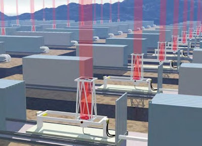
Moving on to a larger scale in wireless power transfer, a prototype aircraft called SHARP which flies using energy transmitted from the ground has been developed. Laser propelled spacecraft is another field under research. The company Lightcraft Technologies aims at developing spacecraft which will be powered by laser beams directed from the earth. The idea is to use the laser beam to rapidly heat and expand air which in turn will propel the spacecraft. This eliminates the need to carry fuel, which is the heaviest component in a space craft.

source : popular science

Using microwaves to beam power from solar power stations in space to the earth is another idea that is under consideration. Beaming power to earth from space has some environmental benefits but it poses a lot of challenges. Safety also would be a major concern in such an arrangement. Starting from handheld devices, wireless power transfer will one day be used in all our energy needs and will give rise to a truly wireless future.


Tuesday, July 10, 2012

Magnetic Anomaly Based Indoor Positioning

We know that certain animals have the ability to orient themselves and navigate using the earth's magnetic field. Unfortunately humans do not have that ability and therefore humans have to rely on their ingenuity and technological skill for navigation purposes. From early methods of using celestial bodies for navigation to present day Global Positioning Systems, it is technology that has enabled humans to find their way.

These days most phones are equipped with GPS based navigation and location services. GPS however is not very accurate indoors. A company called Indoor Atlas sets out to solve this problem by offering a unique way to navigate inside buildings. This company which is based in Oulu, Finland and Oxford, UK, has developed a method of navigating indoors using the local variations of earth's magnetic field, or magnetic anomalies. These variations of earth's magnetic field depend on several factors such as mineralogical variations in the ground and surrounding magnetic sources. The unique differences in the magnetic field thus created can be detected and used for navigation purposes.

Most of the smartphones today are equipped with magnetic sensors that enable them to act as digital compasses and are used in mapping and augmented reality apps. these magnetic sensors in smartphones can detect the the said magnetic anomalies. The system Indoor Atlas has developed works in 3 stages. First the users are allowed to add buildings to an online mapping application developed by the company. Then users can use their smartphones to map the building by walking around the building using their smartphones. The phones will detect the magnetic signature and upload the magnetic data to the mapping application. The final step is using mobile applications to use the uploaded magnetic data for navigation purposes. The magnetic data can be downloaded to any device running the application and by comparing the data with the actual magnetic signature positioning can be done. The accuracy of this positioning technology is within 0.1 and 2.0 metres.

This method has several advantages over existing methods that are presently used to navigate indoors such as wifi or radio access points. Unlike these methods, magnetic anomaly based positioning does not require additional hardware or infrastructure. It also won't be affected by radio blackouts or satellite disturbances. It is also interesting to see how this technology will be used in augmented reality applications because there's a lot that can be done with magnetic data if readily available. This technology has a lot of potential to become a groundbreaking success.

magnetic anomalies can be used to navigate inside buildings

More information : http://www.indooratlas.com/
http://web.indooratlas.com/web/WhitePaper.pdf


Monday, March 5, 2012

Using Bacteria to generate Electricity

It may sound like science fiction, but its actually a possibility that is under extensive research at the moment. The bacterium named "Shewanella" has the unique ability to reduce metals and some other compounds. This reduction process requires electrons to be supplied to the material that undergoes reduction. In order to achieve this, The Shewanella bacterium produces electrons and transfers them beyond its cell membrane to the material by secreting certain proteins. Since a flow of electrons is essentially an electric current, this means that this bacterium is capable of producing electricity, in theory at least. Currently research is being conducted to find ways to exploit this unique ability of the Shewanella bacterium to produce a stable source of electricity. If properly developed this can lead to a very effective and environmentally friendly alternate energy source and could give rise to other technologies such as fuel cells of biological origin.

Shewanella  (image from wikipedia)

Sunday, February 26, 2012

Earth's Structure

In a previous post of mine named Onion Earth I explained how the earth has a layered structure somewhat resembling an onion. The earth has several layers such as crust, mantle core, asthenosphere, mesosphere etc. Some of these layers overlap each other and thus can create confusion. This problem could be avoided by classifying these layers in two ways, one based on the Chemical composition and the other based on the physical properties.

Based on Chemical composition, three layers are identified.
1. Crust  -  Abundant in elements Si , O, Al, Mg, and Fe
2. Mantle  -  Mainly Fe, Mg, Si
3. Core  -  Ni and Fe alloy

Based on the physical properties five layers are identified.
1. Lithosphere  -  Rigid outer shell. Comprises of the crust and uppermost mantle
2. Asthenoshpere  -  Shows plastic behavior. Lithosphere "floats" on this layer. 5% of rocks in this layer is molten
3. Mesosphere  -  Extends from about 300km to 2000km beneath the surface. Solid
4. Outer Core  -  Molten. Rotates around the inner core and produces the earths magnetic field
5. Inner Core  -  Extreme pressure causes it to stay solid despite the high temperatures

Source : http://www.tulane.edu/~sanelson/images/earthint.gif

Tuesday, December 6, 2011

The unseen side of Graphite mining

Graphite is a major export of Sri Lanka and is mined at two places in the country namely, Kahatagaha and Bogala. Sri Lanka is the only country in the world where crystalline graphite or lump(vein) graphite is mined underground. The graphite such mined is also of very high quality and is very pure-99%pure C.

Graphite -image from Wikipedia


In a very brief report I wrote about the graphite mining practices in Sri Lanka, based on an investigation carried out at the Graphite mine in Kahataga, I concluded that no overall damage to the environment was done. This was because graphite being a natural product and is essentially pure carbon which is not a toxic substance, it cannot do any harm to the environment. However further research and more thought put into the matter shows that I couldn't have been more further from the truth. Graphite mining, just like any other mining has a considerable impact on the environment and can lead to catastrophic result if preventive measures are not implemented.

Mining graphite involves the use of explosives to crack open the rock joints and to expose the graphite. The amount of explosives used in this process is often more than what actually is required and therefore ends up creating damage to unintended areas as well. this process also result in the release of dust and very fine particles of Carbon into the atmosphere causing air pollution. This can lead to the deterioration of   the health of workers and people living in the vicinity.

Mining graphite is followed by the processing at the site itself. This processing of Graphite also has a negative impact on the environment of its own. In addition to releasing a larger amount of fine graphite particles into the atmosphere the graphite powder spillages can cause soil contamination and cause harmful effects to flora and fauna.

The underground mining process has a separate set of impacts. The emptying of fissures in the rock and the separation of rock joints can cause water to seep through them and eventually lead to landslides that can destroy the whole area. Furthermore the structure of the dug mine can result in the alteration of water tables causing a heap of environmental impacts. Disturbing the natural water cycle and introducing contaminants can cause damage to both nature and humans. 

To avoid or minimize these harmful impacts, the mining will have to be done after thorough planning with thought given to the environment as well as economic benefits. After mining the land will have to restored to its previous state to bring back the balance. Care should be taken regarding the the chemicals and explosives used in the process and also the wastes generated and discharged. By adopting these practices and through implantation of concepts like cleaner production Graphite mining can be made more environmentally friendly.

Sunday, October 16, 2011

Environmental Engineering

Environmental Engineering was formerly known as Sanitation Engineering and was a subdivision of Civil Engineering. As many new engineering fields, it developed into main engineering stream as its demand and complexity increased. Today it is an vital and interdisciplinary field incorporating many areas such as, Chemistry, Fluid mechanics, Hydrology, Geology and Ecology. Environmental Engineering is mainly concerned with improving public health while protecting nature.
While traditional Engineering focuses on merely utilizing resources and improving living conditions of humans, environmental engineering incorporates the conservation of nature and promoting the well being of humans and other living species in the environment as well. This approach brings out sustainability and overall development.
The key areas of environmental engineering could be identified as,
1. Providing palatable and safe public water supplies in adequate amounts.
2. Control and implement procedures to minimize water soil atmospheric and noise pollution.
3. Recycling waste where possible and proper treatment and disposal of solid and liquid wastes.
4. Implementing procedures to minimize the overall footprint.
5. Incorporating cleaner production mechanisms to protect the environment and to increase sustainability and efficiency of industries.
Environmental engineering is still an emerging field in developing countries and needs to be given immediate consideration because the efficient use and management of the earth's resources will aid development and help to sustain it.

Monday, August 15, 2011

XRF

This post is about X Ray Fluorescence Spectroscopy. If the Name sounds too complicating or sounds uninteresting feel free to ignore this post. Stephen Hawking says in the preface to his book-"The Universe in a Nutshell", that his publisher advised him saying that the inclusion of an equation or technical details will cut down his readership by half. So he didn't do it. But I'm going to write about X Ray Fluorescence Spectroscopy in this blog, and I don't care about the readership. Besides, at the moment I'm writing this post, I don't have any readers! I 'm writing this as a way of remembering what I learned in preparing a presentation on XRF under the module Analytical Methods.
Back to the topic. When high energy electromagnetic radiation-usually in the form of X Rays, strikes a material, The atoms in the material may get ionized. If the energy is sufficient, an atom can lose an electron from one of its lower orbitals. This causes an instability in the atom and therefore an electron from a higher orbital fills in the gap created by the dismissed electron. This causes a release of energy again in the form of X rays but with lower energy than the primary, incident X rays. These secondary X rays are called Fluorescent X rays, and the phenomenon is named Fluorescence.
This released energy corresponds to the energy difference between the orbitals involved and is unique to the atoms of a particular element. This makes it possible, to identify the elements present in a sample by analyzing its fluorescent X rays. In fact, analyzing here means measuring the energy of the emitted radiation. This method of analysis is called X Ray Fluorescence Spectroscopy.
The XRF Spectrometer consists of the primary X ray Source, the sample, the detector and the computer. XRF Spectrometers are further classified into two types;
1. Energy Dispersive Spectrometers(EDS/EDX)
2. Wavelength Dispersive Spectrometers(WDS/WDX)
In the energy Dispersive type the fluorescent X rays are directly measured and is the faster and cheaper method. The Wavelength dispersive type uses an analyzer crystal to separate the different wavelengths before they are focused into the detector. This method the more sensitive method.
A variety of elements can be identified using XRF Spectroscopy and it is commonly used in Geo Chemical investigations and mineral analysis. Recent developments to this technique and emergence of handheld XRF Spectrometers has brought about its application in fields like forensics and archaeology as well. XRF Spectroscopy was recently used to analyze the painting techniques used by Leonardo Da Vinci in creating his world famous masterpiece-"Mona Lisa".

Sunday, March 13, 2011

Engineering with Responsibility

The crisis the Earth faces today is not a secret, almost everyone knows about it but very few take it seriously. Chances are that someone reading this post might also disregard this by saying "just another global warming message....".

However, the problems we face today are not limited to global warming... Pollution is at an all time high, Several species have become extinct or are in the brink of extinction, Natural disasters are becoming increasingly common, the list goes on... Clearly there is something wrong, and we humans are responsible.

Our actions, especially engineering ones have disturbed the "balance" in nature causing ecosystems to fall apart and create catastrophe in the process. All disasters we face today are either caused by us, or its destructive effects are magnified by our actions. For example, Sea erosions and tsunamis hit us harder because we excavate and remove all the natural coral reefs in the coastal area which would otherwise serve as a very effective natural wave breaker. Also filling of marsh land increases the likelihood and severity of floods.

But some people justify these actions by saying that it is necessary for development and improvement of our lifestyle... or these are minor side effects of engineering a better world. All these claims are false. How can we say we are developed when we face natural disasters almost everyday? Engineering that does not go hand in hand with nature is not engineering but "Reckless building".

Engineering encompasses the ideas of creating with care and concern for the surroundings, managing resources efficiently, and ensuring sustainability. Engineering which neglects the above aspects cannot simply be called Engineering. Fortunately, as of recently more attention has been given to this area resulting in looking for ways to protect nature and the environment. Emergence of new fields of Engineering such as Environmental Engineering and Earth Resources Engineering is a promising trend.

It is very important that we take the task of protecting our earth very seriously. Engineers need to work with responsibility. The only way of improving ourselves is by protecting nature and using its resources carefully and efficiently.

What we should understand is that all the resources on earth are limited. Therefore we must use them with extreme care. After all, Earth is all we have got, We don't have another planet to go to...
see what I mean: http://www.oneearth.org/